The Adams Block

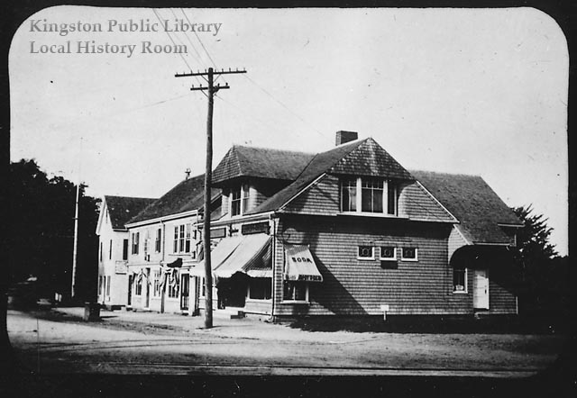
The Adams Block, circa 1900

The original Adams Block consisted of avariety of buildings picked up here and there by Horatio Adams, moved onto Summer Street and joined together in a new kind of retail conglomeration. A novel idea in the 1840s, the business block was a bold experiment. The nature of the structure, however, made it a fire trap and when fire did come, considerable damage resulted.
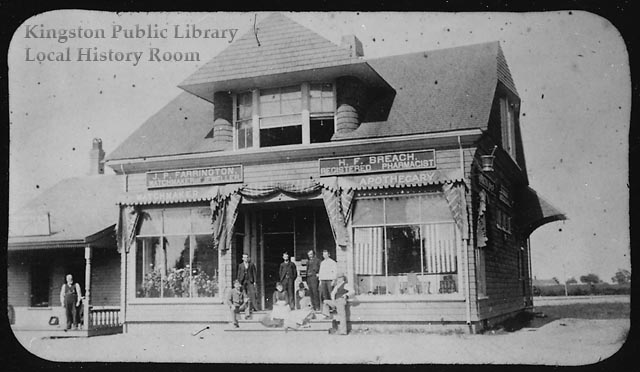
The Adams Block, showing Farrington the Watchmaker and Breach's Apothecary, circa 1900

The main building shown here sat on the east side of Summer Street on the Stony Brook side of the railroad tracks. In the early part of the 20th century, the apothecary of H.F. Breach, Registered Pharmacist and J.P. Farrington, Watchmaker & “Jeweller” occupied the ground floor of what had previously been Samuel E. Cushman’s barn, previously located on the site of the railroad station (now Solstice restaurant). On the upper floor, Mr. Adams provided rooms for a number of small businesses including dentist Dr. George Baker and ladies tailor George Bradley. In later years, Miss Annie M. Marsh set up her dressmaking concern and Dr. Carl Stegmaier took over the dental office upstairs. Another building (formerly a blacksmith shop) housed the fish market with bins that drained directly into the Stony Brook which ran below the building. Later raised to two stories, this structure housed lawyer John T. Smith’s shoe store.

Harry West’s harness shop and a series of grocery and meat concerns later absorbed by Steele & Farrington, occupied additional buildings in the Adams Block. Upper rooms were rented to the Men’s Social Club and the Arrananuchs Club for boys. Beyond was the G.A.R. Hall, later Esther’s Restaurant and today a hair salon.
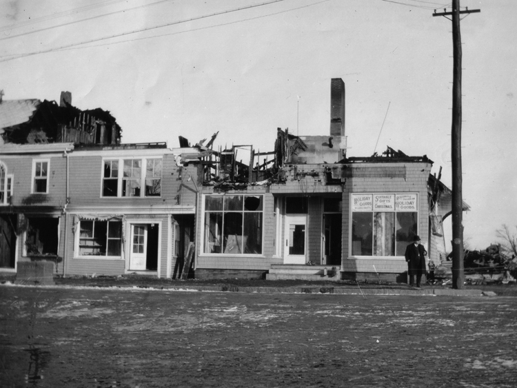
The Adams Block fire, December 28, 1911

On the night of December 28, 1911, fire wrecked most of the buildings except the north end. The damaged stores were rebuilt into one continuous single-story building, still standing today. Despite the devastation, Mr. Adam’s experiment certainly proved a success as the “Block” has been the center of Kingston business through god times and bad for more than a century and a half.

Sources: Lantern slide card file, Emily Fuller Drew; Major Bradford’s Town, Doris Johnson Melville (Town of Kingston, 1976).
“The White Rose of Savoie” tradition

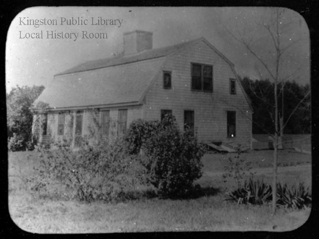
The "Squire Holmes" house, Lake Street, 1890

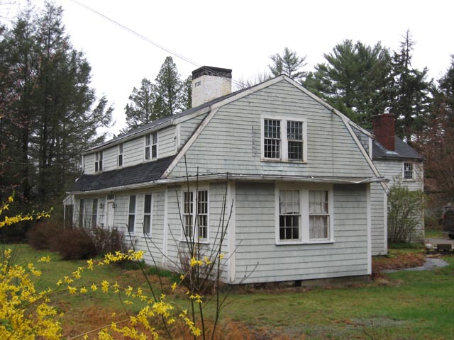
The house now known as 53 Lake Street was once the home of “Squire Holmes” whose father Jonathan Holmes Sr. built it at the time of his marriage to his second wife, Rebecca Tilden in 1752. Although it was a small structure, it was a double house and easily accommodated two families.  In 1773, “Squire” Jedediah Holmes, son of Jonathan Sr., married Sarah Adams and they moved into this house with his step-mother.  Their descendants lived in the house for many generations.    The tale is told that Sarah , the “grandmother” to later generations,  had planted  a rose at the front  doorstep when she came as a bride to live in the house.  Later daughters of the house took slips of this “white rose of Savoie” from the original to plant near their marital homes, bringing the familiar to the new.

The view of 53 Lake Street above dates to around 1890; the one below from April 2008.  In the newer photograph, despite the additions to both sides and the rear of the house,  as well as front and back dormers, the original small structure can still be seen.

53 Lake Street, 2008

Source: Lantern Slide card file, Emily Fuller Drew.

The Old Bay Path

The Old Bay Path
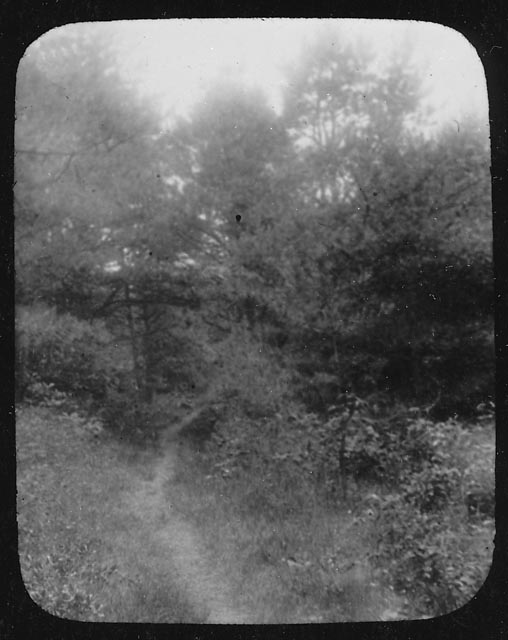
Well before the Pilgrims landed, the Native Americans of southeastern Massachusetts had an extensive network of  well-worn trails, among them the Old Bay Path shown in these two lantern slides.  By 1637, the colonists had adopted the Bay Path as the main highway through Kingston. Eventually the route became a  private road for the Bradfords, then  reverted back to a foot path between Stony Brook village (today’s Summer Street neighborhood) and the settlement at Island Creek once the Boston Road (now  Summer Street, or Route 3A) was laid out in 1708.

The Old Bay Path, ca. 1900

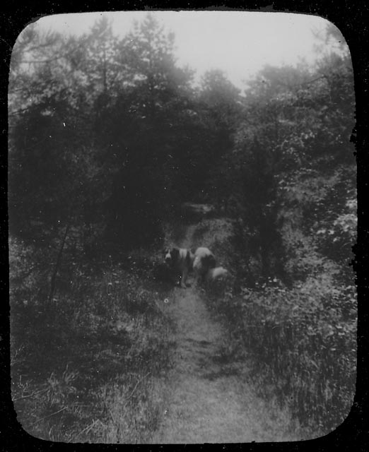
Around 1900, the fields through which the path ran were purchased by private interests, the trees and bushes  cut down,  and a sand pit opened nearby;  soon just a vestige of the old path remained.  The lantern slide below shows the handsome Old Shiloh on the path.  Old Shiloh lived with his mistress Miss Charlotte Cutts on Brewster Road; the path ran close to their home, from the Stony Brook schoolhouse to Miramar.

Old Shiloh on the Old Bay Path, ca. 1900

Although the Bay Path connected first the numerous Native American villages, then many of today’s South Shore towns, it began in our town, specifically in what was once the village of the Patuxet, near the present Kingston/Plymouth line. From that point, the path divided, with  one branch following today’s Main and Crescent Streets  and another going along the shore of Rocky Nook via the present Howland’s Lane  to the Jones River.  Here the water level determined the method of crossing:  stepping stones at low tide or skin boat at high tide.  As late as 1900, evidence of this branch of the trail was still visible, crossing the Jones River between the Poorhouse and the boat houses on Landing Road , continuing past the Bailey Playground tennis courts  and across the ballfields —  once a low, wet area now filled in — up the hill to Summer Street , then over to Maple Street, left  at Bradford Road, onto Foster’s Lane  and finally along  Brewster Road.  Other paths intersected the Bay Path here, continuing on to Island Creek and other communities.  The Bay Path itself continued  along Tarkiln Road into Duxbury near the Tree of Knowledge , running past the Twin Schoolhouse and  north to other  villages.

Little did those Patuxet realize that many years later we would still be using parts of their well worn trail, and even less, perhaps, do today’s travellers realize just how old the roads they follow actually are.

Source: Emily Fuller Drew Manuscript Collection  MC- 16 2.1  Early Roads and Trails.

Treasure in a Shoe Box

Treasure in a Shoe Box

Among the treasures describing the history of Kingston that Emily Fuller Drew bequeathed to the community is a common ladies shoe box.   The box itself probably qualifies as an antique on Ebay, but the real value lies in the contents: hundreds of 3″ X 5″ cards. On each is handwritten information describing the many lantern slides of the JRVHS, as well as the duplicate images in other Local History Room collections.

Here’s why it’s so wonderfully important.

First, take a look at lantern slide #30.

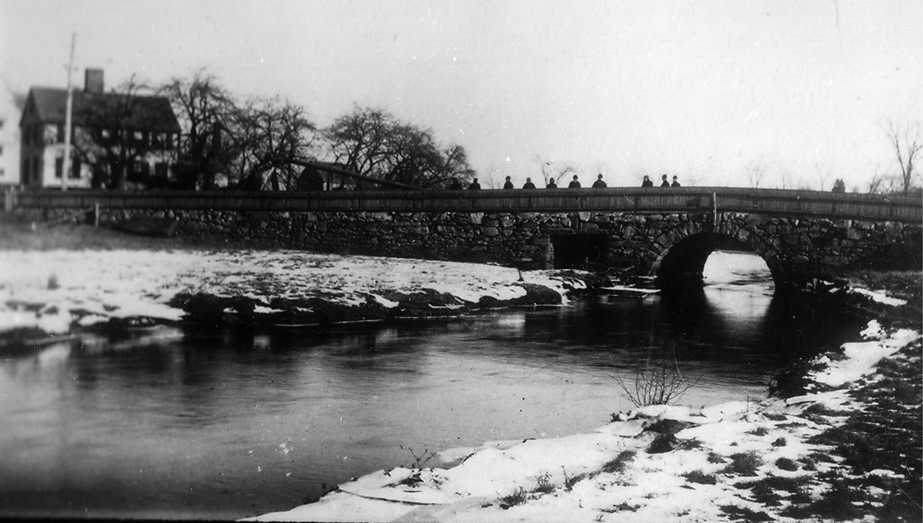
 Great Bridge over Jones River, circa 1890
Great Bridge over Jones River, circa 1890

The actual slide itself has no information (the caption is added to the scan), but we have a small notebook called “A Library of Lantern Slides” that provides something more.

Selection from the notebook, ca. 1938

Informative, but very, very basic.

Now, the treasure:

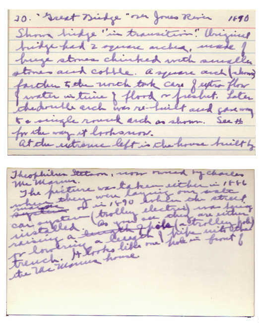
Emily Fuller Drew's notes on Lantern Slide 30, ca. 1935

And to bring this treasure to light, to make it relevant and useful, here’s a transcription, not only because reading Emily’s handwriting can be a challenge but also because the electronic text is searchable.

30. “Great Bridge” over Jones River, 1890.  Shows bridge “in transition.” Original bridge had 2 square arches, made of huge stones chinked with smaller stones and cobble. A square arch (shown) farther to the north took care of extra flow water in time of flood or freshet. Later the double arch was rebuilt and gave way to a single round arch shown . See #   for the way it looks now.

At the extreme left is the house built by Theophilus Stetson, now owned by Charles McManus.

The picture was taken either in 1866 when they were laying our water mains or in 1890 when the street car system (trolley electric) was being installed. As you see, they are either raising  a pole (a trolley pole) or lowering a length of pipe into the trench. It looks like one pole in front of the McManus house.

Now, despite the new questions that spring to mind (what # does she mean? when is “now” given that the cards aren’t dated?  1866 or 1890?), we know a lot more than we did before, not just about this picture but about the bridge itself, and the house, and the projects Emily mentions.

The second major phase of our ongoing project to digitize our local history materials and put them online for everyone to explore is to find as many descriptive sources as possible, like the shoe box, and connect them electronically to scans of the photographs.  In the first phase, every one of the more that 7,000 photographs, lantern slides and other pictorial materials was appropriately housed,  individually numbered and basically described.  Now, however, we need to draw electronic connections among the collections and show this wonderful tangled web of Kingston history online.

One great example is the database of buildings we are creating from the 1998 Kingston Historical Commission House Survey.  The information sheets for each house fill nine big notebooks; each record has been annotated and connected to photographs and other collections and resources over the last decade.  To this “modern” information, the Local History Room volunteers are transcribing Emily’s notes from the shoe box, along with other historic data,  so that for many houses and places and people and events we will have comprehensive, centralized, searchable  information to linked to pictures — the whole story of a bridge, a house, a place illustrated.  This will be a long journey, but please come along for the ride!