The Henry R. Glover Water Trough at the Point, Main Street and Summer Street, c. 1925
In 1888, Henry R. Glover, a wealthy manufacturer of mattresses and “curled hair” from Cambridge, donated the “Henry Glover Watering Trough” to the town for public use. It was placed, and remains, at the Point, that triangular plot of land at the intersection of Main and Summer Streets. Glover was the son of Rev. Samuel Glover, a Baptist minister, who raised his family in the Samuel Foster House on Summer Street opposite the Point. The trough was a place for horses and dogs to drink after the town dismantled and covered the Point Well.
Source: Image from the Local History Room Image Collection IC7.
Elbridge G. Winsor house at 60 Main Street, c. 1905
In this photo, a group of people (unidentified) appear to be enjoying the shade on a nice, sunny day. One of the women is holding a small dog in her arms. They’re gathered in front of the Elbridge G. Windsor House at 60 Main Street, built around 1860.
Source: Image from the Delano Photograph Collection IC11.
Happy Arbor Day! Here are a couple snapshots of some lovely trees from the orchard behind “C. Drew’s house” on Summer Street. C. Drew either refers to Charles Drew or Christopher Prince Drew, co-founder of C. Drew and Company, both of whom lived on Summer Street.
Orchard behind C. Drew’s house, c. 1925
Source: Images from the Emily Fuller Drew Collection (MC16).
Seth Washburn House, corner of Evergreen and Summer Streets, c. 1865
In the Local History Room we have a number of stereoscopic photographs, known as stereographs or stereoviews. These prints feature two nearly identical images, side by side, typically mounted on a 3.5-by-7-inch card. When viewed through a stereoscope, they create the illusion of a single three-dimensional picture. They were popular among commercial and amateur photographers from the late 1850s to the 1920s.
The three stereoviews featured here belong to a series called “Views of Marshfield and vicinity” by M. Chandler of Marshfield.
Main Street, looking south, c. 1865
Thomas Hill, looking north, c. 1865
Source: Images from the Local History Room Image Collection (IC7).
Ye Kyng’s Towne Sweetes, Home Made Chocolates and Bonbons, Kingston, Mass., c. 1930
Around 1907, Carrie W. Hall and Sarah DeNormandie Bailey began a candy business called Ye Kyng’s Towne Sweetes, which they operated out of the house owned by the Hall family at 215 Main Street (below). Miss Hall managed the manufacturing, while Mrs. Bailey managed the sales. By 1910, they employed 8 women year round and up to 13 during the busy summers. Not only did they sell candy, but also other small items, like baskets or baby socks, made by Kingston women. They opened tea rooms in the two parlors.
215 Main Street, 1972
In 1920, their growth necessitated moving to a second, larger location: the building which was previously George E. Cushman’s store at 193 Main Street (below). They sold their candies not only in this shop, but also in stores across Southeastern Massachusetts. During the time that Ye Kyng’s Towne Sweetes was at this location, Isaac and Dorothy Hathaway took over operation of the business.
193 Main Street when it was still George E. Cushman’s store, c. 1902
Ye Kyng’s Towne Sweetes closed sometime between the late 1920s and early 1930s, and the building was left vacant until George Cushman’s son, Charles, converted it into apartments.
Sources: Mary Hathaway Collection (MC21). Images from the Mitchell Toabe Papers (MC18), the Local History Room Image Collection (IC7), and the Jones River Village Historical Society Collection (MC29).
Ancestry is one of the many digital resources available through our library. It allows you to search through many types of historical records, including census, military, immigration, and vital records, among others. This makes it a fantastic resource for genealogical research.
Standing portrait of Mary Trow (1871-1947)
Take, for example, this panel card (above) featuring Mary Trow. It’s one of a number of images for which we’ve been able to identify the subject(s), despite it not having a caption.
Basic search for Mary Trow using Ancestry
By simply inputting her name and location in Ancestry’s search fields, I was able to learn a bit about her.
Mary Lewis Trow was born on August 27, 1871 to Charles and Georgianna Trow. She had two younger siblings, Harris (b. October 22, 1876) and Eugenia (b. March 28, 1886). Her father was a printer who was born in Cambridge, MA. They all lived with Georgianna’s father, Daniel Cushman, a ship carpenter.
According to census records, Mary started working as a reporter for the daily paper sometime between 1910 and 1920, an occupation she held for over 20 years. She continued to live with her sister, Eugenia, on Second Brook Street (image below) up until she passed away in 1947.
Cushman-Trow House, 55 Second Brook Street, 1939
Just from a name and a location (or more information if you have it), Ancestry can often provide a bounty of information, or at least a starting place for further research.
Full access to Ancestry Library and American Ancestors, another digital resource, is available at the library. Stop by to learn more and to try them out for yourself.
Source: Images from the Local History Room Image Collection (IC7).
Sometimes you come across an image that really makes you wish someone had written a caption. Here is one such photo.
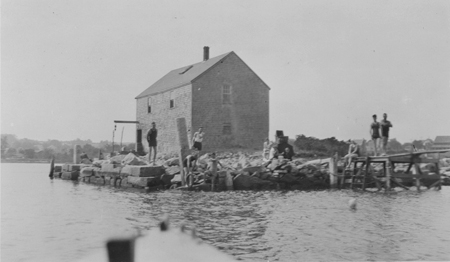
With Delano’s Wharf in the background, we know that the photo was taken on the edge of Kingston Bay. The man stooped over the water resembles Charlie Delano (1837 – 1903) who fished and clammed in the area. But what is he doing with that bird? Catching it? Releasing it? Giving it a rinse? Added to the puzzle are the expectant looks from the four by-standers to the left.
Any ideas?
Source: Image from the Delano Photograph Collection (IC11).
Missing the warm weather yet? Now that we’re halfway through winter, spring is right around the corner.
280 Main Street, around 1900
Take a look at this beautiful bed of asters in front of the house at 280 Main Street, built around 1897. The woman on the left is Martha Maglathlin. On the right you can see the fork of Wapping Road (left) and Pembroke Street (right), with the public watering trough at the point of the intersection.
Source: Image from the Local History Room Image Collection (IC7).
Gravestone of Major John Bradford, taken by Emily Fuller Drew circa 1925
Today marks the 281st anniversary of the death of Major John Bradford, as he died December 8, 1736.
The inscription on his gravestone reads:
Here lyes y body
of Mayjear John
Bradford who dec
Decbr y 8th
1736 in
y 84th year
of his age
he lived near 62
years with his wife
Gravestone of Major John Bradford, taken by Emily Fuller Drew circa 1925
Major John Bradford, born February 20, 1652, was the grandson of Governor William Bradford of Plymouth Colony. He married Mercy Warren in 1674, with whom he had ten children. Major Bradford likely earned his title during King Philip’s War (1675-76).
Major John Bradford is also remembered as a benefactor of the town, as he gave 14 acres of land to the North or Jones River Precinct of Plymouth (now Kingston) in 1717 for the purposes of a “Burying Place,” a “Training Field,” and a “Meeting House” — now the land on which the Old Burying Ground, Training Green, First Parish Church, and old Town House sit.
Major John Bradford House, taken by Emily Fuller Drew circa 1925
The Jones River Village Club (now the Jones River Village Historical Society) purchased and restored his homestead at 50 Landing Road in 1921 before opening it to the public in August of the same year. It is now open on select days during the summer.
Source: Images from the Emily Fuller Drew Collection (MC16).